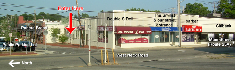
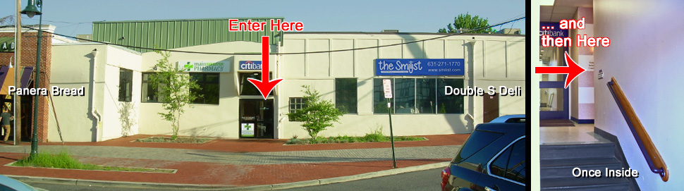
DIRECTIONS  TO  HUNTINGTON


Start here with  Written Directions

Go down to  Map

View as  printable page

Our office is in Health Works - at 14  West Neck Road in downtown Huntington, just north of the intersection of Main Street (Route 25A) and Woodbury Road.  The continuation of Woodbury Road north of Main Street is called West Neck Road.  An easy-to-find landmark on that corner is a CitiBank, our next door neighboor.  We share our space with holistic dentist Dr. Israel Brenner in the  Health Works office.  Parking is available behind the building in a free public lot.  To enter this parking lot, once traveling north on West Neck Road, make the first possible right turn - immediately after a deli with a bright red awning.  Park as near to this entrance as possible, on the far western (uphill) end of the lot.  You may need to travel down one traffic isle and up the next to find a parking space close by.

Between the side of the deli and to the right of a restaurant "Noma" (also having a red awning) is a tall glass entry with double doors and numerous doctors listed on them.  This is the main entrance to our office.  Go up several steps to a landing we share with CitiBank's rear entrance.  Follow the signs for Health Works to the right.

Entrance from West Neck Road is generally not available, as this door is often locked during our office hours.  Wheelchair accessibility can be arranged through this door when we are notified.


COMING FROM NYC, QUEENS, BRONX, AND NASSAU COUNTY:
Travel along the most appropriate freeway to reach either the Long Island Expressway or the Northern State Parkway traveling eastbound just past the Seaford / Oyster Bay Expressway (Route 135).  If on the L.I.E., get off at Exit 45 and follow the exit ramp loop fully until you merge onto Manetto Hill Road northbound.  If on the Northern State, get off at Exit 37 and make a left turn at the traffic light onto Manetto Hill Road northbound.  The two highways are so close to each other here that from this point the directions are the same...

You soon pass under the bridge for the L.I.E. and immediately after come to a "T" intersection - Woodbury Road.  Make a right onto Woodbury and stay on this road into Huntington.  The road narrows to one lane 1.5 miles later, after it crosses Jericho Turnpike (Route 25), and starts winding downhill.  At the bottom of this long downhill ride, at a large intersection, the road bends right, passes by the unmarked parking lot for the Long Island Railroad, and starts to travel steeply uphill.  2.1 miles after crossing Jericho Turnpike, before you crest this uphill climb, you need to make a left turn to stay on Woodbury Road.  This turn is marked with its own turn lane and traffic light.  [Caution:  If you miss this turn, you soon reach the top of the hill and the road, now called Pulaski Road, runs flat and straight through open meadows.  Please turn around and make the turn onto Woodbury.]

Still on Woodbury Road, 2.5 miles later, you cross over Main Street (Route 25A) in Huntington onto West Neck Road.  The total travel time from the L.I.E. / Northern State to our office is about 15 minutes.  From here, refer to the local directions at the top of the page.


COMING FROM SUFFOLK COUNTY:

Travel along the most appropriate freeway to reach either the Long Island Expressway or the Northern State Parkway traveling westbound shortly after the Sunken Meadow / Sagtikos Parkway.  If on the L.I.E., get off at Exit 51 and turn northbound onto Deer Park Road, Route 231.  After less than 2 miles, you will pass under the Northern State, and immediately after Deer Park splits into an East and a West fork.  Follow the signs for the west fork, Route 35, and turn left at the light.  If on the Northern State, get off at Exit 42N and follow the ramp straight through the first traffic light (Deer Park Road East) and merge onto Route 35 (Deer Park Road West).  The directions are the same at this point...

Traveling west/north on Route 35, you will cross over Jericho Turnpike (Route 25), when the road changes its name to Park Avenue.  After 4 more miles and a long downhill stretch, turn left onto Route 25A.  This slanted intersection is distinguished only with an old Mobil gas station on the near right corner.  Route 25A shortly becomes Main Street in the village of Huntington, where you soon cross the key intersection of New York Avenue (Route 110).  Travel beyond that three more traffic lights, nearing the western end of town, and turn right onto West Neck Road.  On the right corner of this intersection is a new CitiBank branch.  (If you miss this turn and pass a RiteAid Pharmacy on your right, you'll know to turn around.)  From here, refer to the local directions at the top of the page.

Caution:  Avoid taking Route 110 into Huntington if at all possible.  Though the road is well known by many, the congestion is usually severe and is made worse by frequent traffic lights.

Click anywhere below to link to an interactive zoom in/out map.  Note - Expedia puts the red pin
a half-block too far north (up) and on the left side of the road instead of the right side.

www.expedia.com